Learning archaeological fieldwork is an immersive experience where teamwork is essential.  It takes weeks of work before a person can begin assembling the clues from each discovery into meaningful pictures of the past. As a result, students should expect the work to be exacting, often slow, and physically challenging, as one develops professional skills over time. We work eight-hour days in all conditions, five days a week (Monday through Friday) throughout any of the course. All that time is essential to the process of learning tools and techniques, as well as piecing together the clues of Bornholm. Students should expect to do the actual field work instead of watching other people work and tell you what it all means. Every day, each person adds an important piece to this large, multiyear, interdisciplinary jigsaw puzzle that is rediscovering Bornholm and its community.
Academic credits and courses
Universities and colleges partners of our program and courses issue the academic credits (undergraduate, graduate level and amateurs) to our students which then contributes to each student’s degree at their home university.
Academic credits and courses
Universities and colleges partners of our program and courses issue the academic credits (undergraduate, graduate level and amateurs) to our students which then contributes to each student’s degree at their home university.
Filed School Staff and Guest Researchers and Lecturers
 Within the excavation experience students take lectures that provide knowledge in archaeology of the region with well-known archaeologists from several universities and institutes from several countries partners of the Bornholm Museum.
All coursework will be taught in English by leaders in each field.
Seminars-Workshops–courses
The course modules offered will be:
 Training includes: prehistoric and archaeological excavation methodologies, stratigraphy, photogrammetry and localization of spatial distribution of artifacts and structures. Classification, cataloguing, as well as restoration of all the excavated materials (faunal remains, lithic, pottery, etc.).
The training will be held also at the Laboratory of the Museum (located in the historical center of Bornholm).
All coursework is taught in English by leaders in each field.
——
Active Project:
THE VASAGÅRD ARCHAEOLOGICAL & FIELD SCHOOL 2004
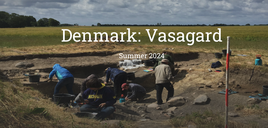
 Denmark: Vasagård Neolithic Archaeology
![]()

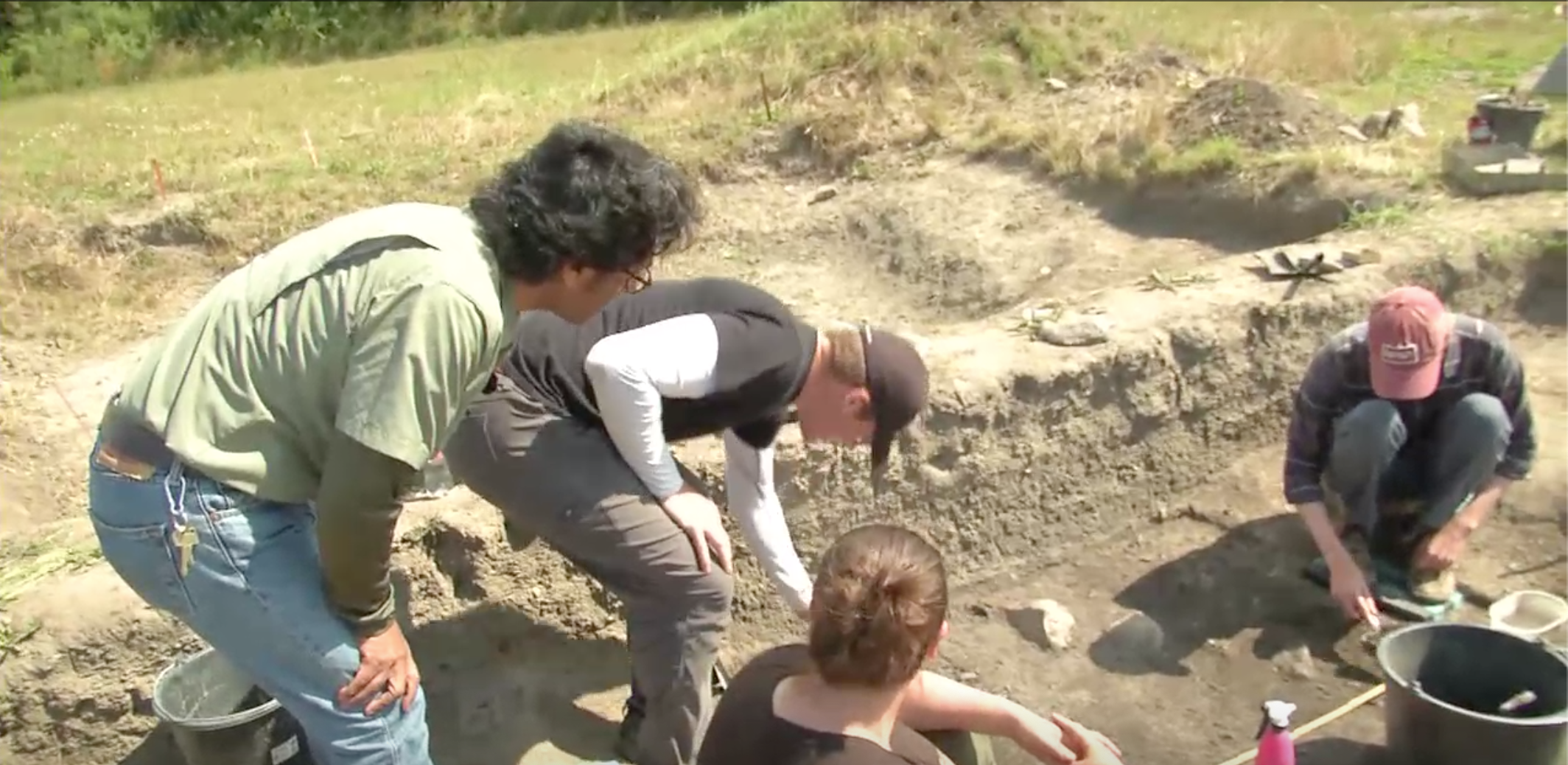
Above: Co-Director Michael Thorsen is working with a student to record the location of important finds using a total station. This project aims to further understand the causewayed enclosures and the circular structures that once stood within this site during the Neolithic period. Flat stones engraved with patterns of radiating straight lines that seemingly have ritualistic purposes and date to c. 2900 BCE have been recovered here.
Lower left: Students are gathered around to observe the process of frottage – a technique in which paper is placed over petroglyphs and carbon paper is rubbed over it in order to copy the negative of the design onto the paper.
Lower right: A student uncovered the tip of a broken neolithic stone axe during excavation.


Crew 2018

Crew 2019

Crew 2021
(Information and photos taken from the IFR Newsletter August 2019/ PhotosBormholms Museum-BARC)

The Vasagård Archaeological Project (VAP)
There are very few excavation projects with the aim of investigating Neolithic settlement sites. This is not due to their scarcity as Neolithic settlements are among the most frequent traces of prehistoric habitation. Despite this, they are often mentioned simply as postscripts when the result of a dig, a barrow for example or an Iron age settlement, is reported. The knowledge that until a few years ago Neolithic settlements were a question of occupation layers and refuse pits explain this disinterest. However, the discovery of Runegård Øst 4, Nrd. Grødbygård and Limensgård (settlements) and Vasagård (causewayed enclosure) stirred an interest with regard to settlement sites and how to interpret them, as well as in investigations of the settlement pattern of which they were a part. In recent years, new information has also come to light, and this has injected enthusiasm into the efforts to cope with the difficult task of gaining a better understanding of Stone Age farmers. At the same time, it may help to solve the different problems posed by Neolithic settlements. From the view point of a rescue operation, it is high time to begin the requisite activities for most of the settlements lie in arable land and are just as threatened as— in fact, far more visible—barrows and megalithic tombs.
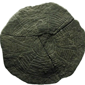 On the island of Bornholm, the highest research priority of all has been given to habitation/activity areas, causewayed enclosures, palisades and the circular structures (nine have been found—seven on the East and two in the West site—but there are certainly more). From the top layer of the causewayed enclosures, 300 broken and complete flat stones were recovered, engraved with patterns of radiating straight lines now called sun stones. But some other areas must be explored.
 For most phases of the Neolithic sites in Bornholm, we still have little knowledge of how causewayed enclosures, palisades, habitation, activity areas and the presence of circular structures (timber post marks in a circular form) developed. Something as basic as the identification of houses/activity areas and circular structures still cause great difficulty. It seems to suggest that the missing evidence will not emerge of its own accord, but that more systematical investigations are called for.
Ideally, the background material recorded information ought to be enough to give some idea of settlement in a given area—a settlement model. Several museums are at present engaged in the drawing up of periodical surveys of settlement that make it possible to take mapped finds as a point of departure. Neolithic settlement sites are, besides, not among the most difficult to trace as scatterings of flints disclose them, and they can very often be dated by finds in the topsoil. The nature of the soil is an important factor when identifying and interpreting traces of activity areas. Neolithic post-holes—if any—are often only faintly discernible and difficult to excavate if the soil is too sandy. The time of the year also plays a part. In dry summer months, both clay and sand are unfit for the horizontal excavation of larger areas.
Only rarely is it possible to assess the potential of a site solely by surface reconnaissance; test trenches or a sq.m. grid must be made. It will then be discovered that at no settlement site are there optimum conditions for investigating all aspects of a settlement and that it is a matter of choosing the method of excavation best suited to the site.
The comprehensive recording and mapping material already collected is being worked upon simultaneously with current fieldwork findings. The preparation of local chronology, based on C-14 dating, is also under way, considering that Bornholm has to some degree undergone a different course of development than the rest of Denmark. During the running of this project, another investigation program was completed in south Scania (within the framework of the so-called Ystad project) where, as in Bornholm, a number of Neolithic settlement sites were excavated. Establishing contact with Swedish archaeologists working with the same problems in an area closely related to Bornholm has been important.
 The main objectives of the Vasagård excavations for the coming season are the following: to pursue the search for information of one of the causewayed enclosures and the circular structures within the site, where we know now conditions seem especially promising. Right from the initial stages of the project, it was understood that conditions for the preservation of organic material were poor throughout most of the island. Therefore, expectations of being able to shed light on the natural environment and agricultural occupations were not high. Yet, certain possibilities began to emerge even in this field. One of the results of the ongoing digs at the settlements was a special find, an assemblage of seeds and ceramic in Bornholm that corresponds to the Funnel Beaker Culture in the rest of Denmark, and also overlaps in time with part of the Pitted Ware Culture and the Early Battle Axe Culture that, in turn, corresponds to the Middle Neolithic A V and Middle Neolithic B I. Similar material was also found in south and south-east Scania. Finds from a particular period are known to come from the settlements of Runegård Øst 4, Nrd. Grødbygård and Limensgård. The Neolithic dwellings at Vasagård and cultural layers fall into two periods, i.e., Early Neolithic B/C to Late Funnel Beaker culture and Middle Neolithic A V to Middle Neolithic B I.
Part of the ongoing excavation in the causewayed enclosures and the later palisade structures led us to the discovery of timber circles (10; with each having a diameter of 6 to 9 m ), adding a new dimension to our research as they would not only help in understanding their use but also figure activity areas at Vasagård. The circular features were dated by objects and C14 to the Late Funnel Beaker culture. Burned knives, axes, pots and seeds were placed with a particular purpose in post-holes as offerings, clearly distinguishing them from the houses. Therefore, our thought led to consider that the timber circles were consecrated by means of offerings. These small but important relics of the past culture and habitat are the result of riddling cultural layers, pit fills, and soil from post-holes, and now a strict, routine of excavations will continue in our field season when we excavate the Cultural Layer II (3000 BC). The same applies to the collection of soil samples for different studies.
http://ifrglobal.org/program/denmark-vasagard/?portfolioID=1226
![]()
SORTE MULD: AN EARLY VIKING SITE IN BORNHOLM, DENMARK
BORNHOLMS MUSEUM/BARC – IFR
COURSE ID: TBA
May 30–June 24, 2022
Academic Credits: 8 Semester Credit Units (Equivalent to 12 Quarter Units)
School of Record: Connecticut College
FIELD SCHOOL DIRECTORS:
Dr. Finn Ole Nielsen, BARC-Bornholm Museum, Denmark (fon@bornholmsmuseer.dk)
Dr. M. Nicolás Caretta, BARC-Bornholm Museum, Denmark (nc@bornholmsmuseum.dk)
MSc. Michael Thorsen, BARC-Bornholm Museum, Denmark (mst@bornholmsmuseum.dk)
MSc. Ditte Kofod, BARC-Bornholm Museum, Denmark (ditte.kofod@icloud.com)

Sorte Muld is located approximately 30 kms from Rønne, the capital of the island of Bornholm in Denmark and approximately 2 kms from the city of Svaneke on the eastern side of the island.
The literal meaning of Sorte Muld is ‘black soil’. Medieval sources mention that this place is also known as ‘the field of gold’, because of the findings made there since early periods.
Sorte Muld was inhabited since the Stone Age till recent times, and this is evidenced by the materials recovered from the top soil over the years, which have been submitted to the Bornholms Museum. However, the most intense use of the area occurred during the Iron Age, especially from the Roman Iron Age through the Migration Period and Late Germanic Iron Age, when Sorte Muld was the supra-regional centre, acting as a unifying force for the surrounding community.
The primary excavation carried out at the site focuses on the main period of occupation, but this particular excavation aims to seek more detailed answers to general questions regarding the Baltic and North European aspects during the Early Viking Age:
- What was the importance of the site in the region during the Early Viking occupation?
- How did they use and/or modify the previous Iron Age settlement pattern?
- What is the relation of the long house to the main temple?
- How did the Viking society residing in Sorte Muld function and develop and what did their everyday life look like?
This new research / field school project at Sorte Muld aims to address these questions. Our goal is not only to explore the richness of the archaeological material found at the site but also to study the history of the Early Viking occupation after the heydays of the site during the Iron Age.
An explanation of the character and composition of the archaeological structures around the temple area is sought and a further dating of these elements will be performed. The need for a phase study is justified as Sorte Muld has a particular cultural-historical importance and must therefore be investigated systematically. Both clarification of structures and dating are important, as previous excavations as well as GPR results and interpretations validate the surmise that continual occupation affected the settlement and building complexity. Dating will be based on a) retailing of the culture layer in square meters and b) AMS dating of suitable material obtained during the 2019 digging campaign. Furthermore, chronological clarification will be based on a) surface coverage of selected sections of the long house area for stratigraphic observations and b) AMS dating of suitable material also provided during the 2019 excavation campaign.
Further, it is important to note that the GPR analyses seem to indicate that larger houses / hall buildings are located just south of the temple’s enclosure, and possibly, also to the north. Identification, dating and architectural clarification of these buildings are crucial to understanding both the economic and social structures of the Sorte Muld complex during the Viking era, as well as providing a further basis for its comparison with other contemporary and similar sites, beyond what is currently possible based on the rich find material.
It is also of our interest to understand the interactions with other communities around the Baltic, their technology, economy, religion and social organization. More site-specific questions concern the continuity and discontinuity of habitation, borders and spatial organization of the settlement through the time after the Iron Age and during the Viking period.

Sorte Muld-IFR Crew 2021

